Discover the vastness ...
Just start hiking. With friends, your family or alone. Step by step discovering space and serenity. Discovering yourself step by step and at the same time experiencing Tyrol in a special way: as a historical route, a mystical pilgrim path, an impressive panoramic route and a very special ecosystem.
Starkenberger Panoramic Route (total)

Section 1: Landeck Castle - Kronburg
Today, we’ll be walking along forest and meadow trails, past mountains and lakeshores, from Landeck Castle to the pilgri…
Read more
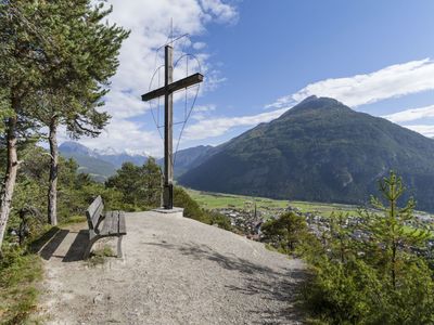
Section 2: Kronburg - Mils
Deeply engraved into the rock, indelibly in memory.
Read more
Section 2a: Kronburg - Imsterberg
Deeply engraved in the rock, indelible in memory.
Read more
Section 3: Mils - Imst
Test the waters!
Read more
Section 3a: Imsterberg - Imst
Washed with all waters
Read more
Section 4: Imst - Tarrenz
Mythical places and wild customs
Read more
Section 5: Tarrenz - Nassereith
Where history began.
Read more
Section 6: Nassereith - Fernpass
If the Loreakopf mountain could tell a story!
Read moreSights and Attractions
Not always only the way is the goal. Sometimes there have to be historic buildings, mystic natural monuments or culinary highlights!

The natural swimming pond is located in the Trams recreational area on a hill between Land…
Read more
Kneipp facility in Mühlsprung (near the fire station) with arm-bath and waterstepbasin!
Read more
The Göfelesee is an idyllic mountain lake at 1,500 metres!
Read more
Idyllic small forest lake ideal for romantic walks.
Read moreMore highlights / sights can be found here .
Accommodation
An overnight stay can do so much more than just sleep well: feel welcome and at home!

Welcome to the nature resort Fernsteinsee! 280.000m² for your recreation!
Read more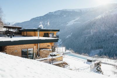
Doris Stadler and Albert Ehrenreich have realized the common dream of a cottage on a sunny…
Read more
Welcome to the Hotel Auderer!
Read more
Welcome at Sport Appartement Schatz in Hoch-Imst!
Read more
Welcome to the Hotel Inn Neuner!
Read moreMore accommodations can be found here .
Marketingmaßnahmen:
MIT UNTERSTÜTZUNG VON BUND, LAND UND EUROPÄISCHER UNION


Follow us on Instagram